


After half of the summer, a long fall, and half of the winter, the city of Charlottesville has published the first draft materials for the new zoning ordinance. The city is referring to these as modules, and the initial installment includes the new proposed zoning districts and the new zoning map.
“The zoning rewrite is part of what we’re calling Cville Plans Together which is focused on updating the future for the city of Charlottesville with a particular focus on community equity and affordability for housing,” said Jennifer Koch of Rhodeside & Harwell in a YouTube video that seeks to explain the new map.
Resources from Cville Plans Together:
- Draft Zoning Districts and Rules
- Draft Zoning Map (.pdf version)
- Draft Zoning Map (interactive)
- Zoning District & Map Overview by Neighborhood
This work has now been underway for three years and saw the adoption of an Affordable Housing Plan in March 2021 and a new Comprehensive Plan in November 2021. The main idea is to allow more places to build housing all across the entire city.
“The new zoning districts correspond directly to the land use areas shown on the Future Land Use Map in the Comprehensive Plan,” reads the introduction to the material that was sent out late Friday night.
If you’re unfamiliar with the Future Land Use Map, it is a map in the Comprehensive Plan that gives a rough sketch of what the city would like to see built over time. The key feature of the Future Land Use Map is the provision of new development rights for almost all properties across Charlottesville. This zoning rewrite is intended to allow those rights to be turned into new places for people to live.
The previous Future Land Use Map adopted in 2013 designated about half the city as low-density residential, which corresponded with single-family residential zoning districts. Those will no longer exist in the new zoning as the General Residential category called for up to three units on most lots.

Other areas that had been low-density residential are now Medium Intensity Residential The draft zoning code splits this into two proposed zoning districts known as Residential-B and Residential-C.
“At a base level, the R-B allows up to 6 units, the R-C up to 8,” the introduction continues.
That’s before any of the city’s new affordability requirements would kick in. If a developer or landowner wanted to build more, they would have to comply with the city’s requirements to construct units that would be guaranteed to sell or rent at less than the market value. All of the units would specifically have to be reserved for households who make less than 60 percent of the area median income.
“There is an inclusionary zoning policy that requires the inclusion of 10% affordable units in developments of 10 or more homes, in any zoning district,” the introduction continues.

All lots in R-A would be eligible to have three dwellings but a total of four if an existing structure is preserved. A total of eight units could be built on R-A property if all of them are qualified as affordable. As much as 65 percent of the total lot area could be constructed upon if there are over four units.
Height in R-A would be restricted to 32 feet, or two and a half stories. There would be no provision for bonus height.
The draft rules for R-B allow for up to 12 units if all of them are below market. Unlike R-A, there is no provision for existing setbacks to still need to be honored. New units could be built within ten feet of the primary street. Construction could be on seventy percent of the lot.
Construction in R-B zones could get a bonus height up to 44 feet for a total of three stories if all of the units are affordable.
R-C would allow a base height of 44 feet or three stories and up to 58 feet if all of the units are affordable. As many as eight units could be built at market-rate if no affordable units were provided, but there would be no provision for bonus height and density. If there are more than 12 units, construction could cover up to 75 percent of the property.
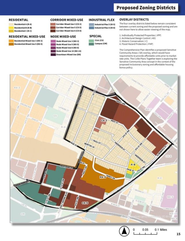
An example of R-B land is most of Cherry Avenue between Cleveland Avenue and Roosevelt Boulevard, with the exception of the intersection at Shamrock Road, a few houses close to Roosevelt Brown, and a 3.81 acre parcel owned by the United States government that’s currently used for an armory.
A look at mixed-use districts
The existing zoning has many different mixed-use districts named for specific areas. The new zoning would make the names more descriptive beginning with Residential Mixed Use 3, or RX-3.
There would be no defined limit on the number of dwellings on the lot nor would there be any specific affordability requirements except for the standard requirement of 10 percent affordable for any development with more than ten units. There would be a maximum of 80 percent lot coverage allowed.
Buildings in RX-3 could be 44 feet tall, or three stories. There could be a maximum of 72 feet if bonus criteria are met. Ground floors must be ten foot floor to ceiling. The draft tables do not specify any minimum requirements for commercial use, or vice versa. These buildings could have a maximum width of 175 feet.
RX-5 is the next step up with a maximum height of 72 feet or five stories without any bonus. The structure could be up to 100 feet tall or seven stories if those criteria are met. These buildings would take up an entire lot as long as a ten percent outdoor amenity space is provided. Structures could have a maximum width of 275 feet.
One area designated RX-5 is the site where the Westhaven public housing community currently stands. Another is the western side of Fifth Street parallel to Ridge Street. Another is at Beacon on Fifth, a private development built as a Planned Unit Development under existing zoning.

The Future Land Use Map also designates other areas as either being nodes or corridors.
The two corridor mixed Use districts are similar to the residential mixed use district which begin to have more definitions for space depending on whether the use is residential or non-residential. Ground-floor residential would need to be a minimum of ten feet with nonresidential ground floors required to be as tall as 14 feet. CX-3 would have a range between a base of three stories and five stories if bonus criteria are met. CX-5 follows the same height rules as RX-5.
An example of CX-5 is the small stretch of East Rio Road within Charlottesville City Limits on land currently zoned for single-family residential. I wrote about that area for C-Ville Weekly last month.
CX-8 could take parts of Charlottesville to new heights. The base height allowed would be eight stories or 114 feet tall. With bonuses that could climb to ten stories or 142 feet.
The eastern side of West Main Street would be an example of CX-8, allowing for taller developments than what is currently allowed under the code. The western side is CX-5.
Another example of CX-8 is the parcel on Ivy Road that RMD Properties would like to build a nine-story building on. The Planning Commission is set to consider whether an exception can be made to allow that to happen under existing zoning. Read my story from January 10, 2023 for more info.
Then we get to the nodes which follow the same patterns as above, with NX-3 allowing the same 44’ to 72’ height range and NX-5 and NX-8 largely following the same as the corridor and residential districts listed above.
Each of these higher-intensity areas have varying rules for window requirements, massing, and other details. Some of these regulate different aspects of the building depending on whether a street is a “framework” street or a “local” street. These are defined in the Streets that Work plan.
An example of NX-8 is the land between East High Street and 10th Street NE in the Little High neighborhood. Another is most of the commercial strip between U.S. 29 and Hillsdale Drive considered to be in the Meadows neighborhood.

The suffixes go up to 10 for nodes with NX-10. These would allow a maximum of ten stories in height or 12 stories if criteria for bonus provisions are met. This is very similar to DX for Downtown Mixed Use which adds different rules depending on relation to the pedestrian mall.
An example of NX-10 is Friendship Court, which is currently being redeveloped by the Piedmont Housing Alliance with investment of city infrastructure dollars. Another example of NX-10 is the land that used to be Vinegar Hill between what is now 4th Street NW and Ridge-McIntire Road.
- There are similar zoning districts for industrial-flex areas with IX-5 and IX-8.
- There are also “special” districts such as Campus (CM) and Civic (CV).
- There are also provisions for “Alternative Forms” such as “Shopfront House,” “Civic Institution,” and “Park.”
Four existing overlay districts would remain in place. These are Individually Protected Properties, Architectural Design Control Districts, Historic Conservation, and Flood Hazard Protection zones.
A new overlay district is proposed for areas marked in the Future Land Use Map for areas prone to displacement of vulnerable populations. Those rules are not included in this module
Specific definitions begin on page 60 with items such as zoning lot and sublot. These are likely going to come into play later, so I conclude this summary with those definitions.
“A zoning lot is a parcel, tract, or area of land established by a plat or other means as permitted by law, which is to be used, developed, or built upon,” reads that definition.
“A sublot is a parcel of land, existing with other sublots on a single zoning lot, intended for the purpose of the transfer of ownership or possession or for development,” reads that one.
Next steps
The overall review will take place for the next few months.
“From now in February into the spring of 2023, we’re going to be sharing the draft ordinance in three parts to obtain your feedback,” Koch said.
One place to start your review is a summary of how these changes would alter each neighborhood. You can access that document here.
There are three upcoming open houses coming up later this month. These will be on February 22 at Charlottesville High School, February 23 at Buford Middle School, and February 25 at City Space. Keep an eye out for the Week Ahead that week for times and more details.
The next module will deal with the standards for each district. These include rules for parking, landscaping, signs, lighting, and other issues. That module is currently scheduled to be released the week of March 13.
After that will be the release of the final module which will take a look at the review processes.
Then the public hearings. Input received now could alter what ends up getting voted on.
To review the rules from the Cville Plans Together team, view the YouTube video. I had hoped to embed that here in this newsletter, but they’ve disallowed that function. So go here.
What do you think?
I am interested in your thoughts and would like to carry on a public conversation throughout this time. Want to be interviewed? Have a story you want to share? Let’s Talk!
Oh wait, that’s Albemarle’s catch-phrase.
Before you go: The time to write and research of this article is covered by paid subscribers to Charlottesville Community Engagement. In fact, this particular installment comes from the February 4, 2023 edition of the program. To ensure this research can be sustained, please consider becoming a paid subscriber or contributing monthly through Patreon.
Discover more from Information Charlottesville
Subscribe to get the latest posts sent to your email.


9 thoughts on “Charlottesville releases first set of new draft zoning rules including new map”