There are several stories waiting to be written about how Albemarle County uses both its designated growth area as well as rural lands. I’ve been writing such stories for nearly 20 years and hope to do so for another 20. Soon-to-be-written segments include summaries of work sessions on the most recent draft of the Comprehensive Plan update as well as the Board of Supervisors’ review of a build-out analysis.
But this story takes a long look at one particular item on one particular agenda of the Albemarle Planning Commission. On September 9, six of the seven members held a public hearing on Riverbend Development’s request to rezone land very close to the intersection of Interstate-64 and U.S 29 to the southwest of Charlottesville. The land is within the growth area.

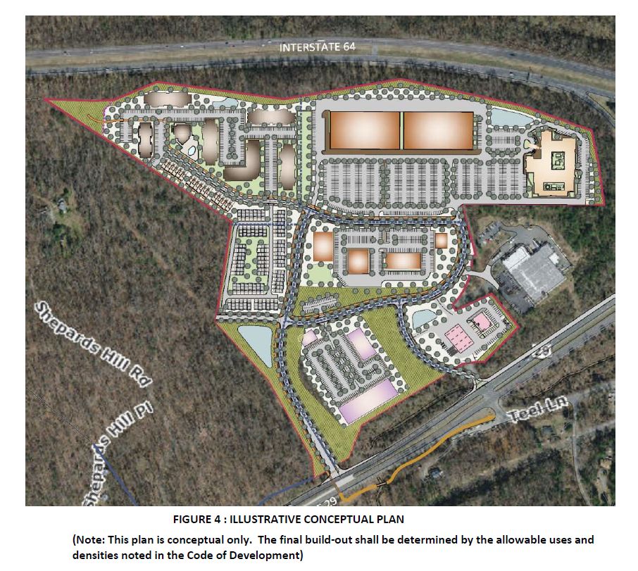
In all, Riverbend is seeking rezoning of about 62 acres of land to the Neighborhood Model District, a category created in the early 2000’s to encourage dense development in the county’s urban areas. Around a third of the land is zoned Highway Commercial and the rest is zoned Residential-1.
“Right now, the R-1 property could yield anywhere from 43 to 68 dwelling units,” said Cameron Langille, a principal planner with the county. The land zoned Highway Commercial would need a special use permit and could have between 279 and 373 units.
To the east is the Virginia Eagle beverage distribution facility which will remain in operation.
To the south is the Sherwood Farms residential neighborhood, a community that has no vehicular connection to the Redfields neighborhood and is in the rural area.
To the west is another set of properties that are in the county’s growth area owned by an entity called Sweetspot of Charlottesville. An original version of this application including one of the parcels but was withdrawn.
Albemarle County owns 340 acres even further to the west after they were donated in 2017 for the future Hedgerow Park. The previous version of the rezoning included an easement to connect to that park, but the new version does not.
“This would be a mixed use development that would allow up to 1200 dwelling units at a density that comes out to 19.2 units per acre gross, or 22.6 net,” Langille said. “They would be proposing 15 percent of the affordable housing units at 80 percent [area median income] if they develop to the full number of units they’re requesting.”
Langille said that would be a total of 182 dwelling units. The rezoning was submitted after Supervisors adopted the Housing Albemarle plan which calls for 20 percent of units to be dedicated.
Riverbend is also seeking a range between 50,000 square feet and 440,000 square feet of non-residential space. The development would extend public water and sewer to the site and that action would not need permission from the Board of Supervisors to connect.
Access would be via two entrances onto U.S. 29 with one of them using the existing Gold Eagle Drive. The second entrance would be to the west and would include a traffic signal.
Riverbend would also construct an at-grade pedestrian crossing and upgrade an existing park and ride lot on Teal Lane, across from the development at the entrance to Sherwood Farms. A pathway would extend to a new bridge that would cross Moores Creek, providing access to trails that lead into central Charlottesville.
A trailhead is proposed in Block 6 to provide access to Hedgerow Park, even though direct access is not guaranteed.
Staff recommended approval.
“It’s consistent with the land use and density recommendations from the Southern and Western Neighborhoods Master plan,” Langille said. “There’s quite a few transportation improvements that are consistent with the master plan that this application proposes, not just internally to the site, but off site.”

What about that intersection?
During the question and answer period before the public hearing, at least two members of the Planning Commission pointed out that the intersection of U.S. 29 and Interstate 64 is one of the area’s most dangerous.
In May 2014, the Charlottesville Albemarle Metropolitan Planning Organization adopted a long range transportation plan that had the description of “full replacement of I-64/US 29 Interchange, includes some improvements to Fontaine Ave Interchange (not full replacement, developer funding). Replacement both for capacity and safety.”
The next year, the MPO submitted a plan to rebuild the intersection in the first ever round of the Virginia Department of Transportation’s Smart Scale funding process. That is a process that ranks projects according to how they satisfy a series of criteria including safety improvements, relieving congestion, and increasing economic development.
When scores came out in January 2016, the project was ranked 282 out of 287 programs statewide and dead last of the 17 applications made in VDOT’s Culpeper District. (read a story on Charlottesville Tomorrow)
The failure to fund such a large project has led to a new philosophy where planners submit smaller projects in the hopes of getting them through the algorithm. Albemarle County obtained funding in the second round for a project to better control the movement from southbound U.S. 29 to eastbound I-64.
“There was a nasty weave, a high speed weave of people trying to get off who are coming from Staunton or people who are getting on, trying to head eastbound,” said Michael Barnes, Albemarle’s Planning Director. “So the purpose of that thing was trying to take that safety concern away with the signals that were proposed.”
However, Barnes said that has not worked out as well as envisioned so VDOT has been taking a look at the intersection anew through a pipeline study expected to be completed next August.
A forthcoming Smart Scale project will finally see the closure of an at-grade crossover for vehicles seeking to get from northbound U.S. 29 to westbound I-64. Instead, vehicles will take a U-Turn at the interchange with Fontaine Avenue.
Developer discussion
Ashley Davies of Riverbend Development said 56,000 vehicles pass the site daily, one of many factors that makes the site suitable to be rezoned.
“It’s a designated mixed use center and it’s also a gateway to the future Hedgerow park and I think a really important trail connection within larger trail networks in the county,” Davies said.
Davies also said there is limited land in the development area and this project is intended to provide balance. She said Riverbend Development could have asked for more than 2,000 residential units but chose not to in part because of the topography.
“We do think that there are lots of reasons to support this rezoning,” Davies said. “The targeted housing options appeal to the unmet needs of county residents. In a location adjacent to the city and uva, there’s commercial and office space that can foster local employment opportunities and strengthen the county’s economic base.”
The plan before the Planning Commission was conceptual and Davies said the idea was to be mixed-use and to create an area of flexibility depending on what businesses wanted to operate at the new community center.
“Some of the things that we’ve been looking at, like Block 2 is like a potential gas station site,” Davies said. “Block 1 might be more like a hotel. Block 4 is more focused on like office opportunities and other retail. Block 3 is more retail focused.
Block 5 and Block 6 would be residential and Davies said there would be a mix of unit types with some for-sale opportunities. She said this property would develop over time much like the Brookhill Development which recently had its Code of Development amended to allow for up to 300 more homes.
Planning Commissioner Julian Bivins noted that the property was once the site of a restaurant called Bren-Wana and later the Hilltop Hideaway.
“That was one of the locations that Black people could go to for entertainment, and it was a place that many of the notorious and notable jazz musicians could come there,” Bivins said, adding it was in the Green Book used to help Black people find safe places when segregation was mandated by the government. Take a look here.
Davies said at the very least there will be a plaque memorializing Bren-Wana as the first Black-owned motel in Albemarle County.
The Code of Development shows a bus stop on the site, but Commissioner Karen Firehock had a practical question.
“What’s your sense of whether you would get service to that site?” Firehock said. “Have there been any conversations with [Charlottesville Area Transit] or any transportation providers? I’m just trying to see what’s the likelihood that I could live there and catch the bus.”
Davies said there have not yet been conversations with any providers and that’s part of a wider conversation about transit in Albemarle County.
Commission Chair and Samuel Miller District representative Fred Missel wanted to know whether the traffic study conducted two years ago took into account recent fatalities in the area as well as the upcoming closure of the median crossing.
“I mean as we know, it’s a really challenging area right now,” Missel said.
Carl Hultgren of the firm Gorove Slade said the last traffic study was conducted in September 2023 and he said the model did include the closure of the median. However, he said the Fontaine interchange is outside of the scope required for study.
Hultgren said the traffic study used figures based on less than the maximum build-out.
“It is common on a project like this and other mixed use projects around town where we don’t know what the final unit count’s going to be at the end of the day,” Hultgren said.
Public hearing
Several people spoke during the public hearing including one resident of the Sherwood Farms neighborhood who was concerned about the additional traffic of a thousand new homes. She said the existing conditions now are not ideal.
“For those people both traveling north and south on 29 and how all of those converge on the failing intersection that we have now, when I come home at 5:15 in the afternoon from UVA, there is a backup that backs up almost as far as Ivy Road,” said Reid Forbes.
Forbes also referred to a staff report that stated Riverbend’s application did not suggest any ways impacts to schools might be addressed.
Another Sherwood Farms resident said she did not think the application was ready and needed more certainty. But she used her time to comment on the proposed crosswalk.
“Surely that’s the most ridiculous thing,” said Norma Deal. “If you’ve ever seen the number of tractor trailers and the rush hour traffic that goes up and down this road, you would be taking your life in your hands even if there is a blinking crosswalk.”
Suzanne Fox lives further down on U.S. 29 and said she was concerned approving this rezoning would mean that development would spread further into the rural area.
“If this starts, I can see it just hopping down 29,” Fox said.
In rebuttal, Davies pointed out the property is in the growth area and the rezoning is consistent with the Comprehensive Plan. She acknowledged there would be more students for area schools but said a partnership is needed to provide more classroom space.
“The Board of Supervisors have acknowledged that school capacity issues are an Albemarle County discussion and not an issue that need to be solved by individual rezoning applications,” Davies said.
Davies said the crosswalk was suggested by Albemarle County staff as a way of getting people to Hedgerow Park in the future.
Davies said if approved this year, the hope would be to get the first phase of the project under construction next year.
“And with that we would be putting in the traffic signal, the multi use path, the updated park and ride facility and at a minimum would get this road all the way up the hillside here and we would have to also do all the lower connections into the existing distributorship,” Davies said.

Planning Commission support for some development, but how much and what kind?
Commissioner Julian Bivins said there is a lack of land in Albemarle County for development but that the Comprehensive Plan has designated this property for that purpose for decades.
“I’m supportive of the project because I think that it is in a location that will help sort of spread out some of the density that we’re, that we’re having troubles with in other parts of the county,” Bivins said.
Commissioner Nathan Moore said Albemarle needs more homes so more people can live closer.
“Albemarle County already has a development area that’s probably too small,” Moore said. “And I would argue that more than one twentieth of our land probably should be open to growth. But this proposal is actually within the existing growth area, so it’s not even relevant.”
Moore said he would support more homes at this location so that the area could develop more like a town with residents in place to support businesses.

Commissioner Karen Firehock said she supported development at the site but did not think there were enough specifics in the proposal before the Planning Commission.
“My greatest heartburn with this site is, is the proposal itself, because I don’t know if I’m voting for 100 units of housing or 1200 units of housing,” Firehock said. “I don’t know if I’m voting for 50,000 square feet of commercial or 440,000 square feet.”
Firehock and others both pointed out that the plan cannot yet guarantee a connection to Hedgerow Park.
Commissioner Lonnie Murray said he liked the connections to greenways that would be made but he doubted anyone living there would walk or bike to work.
“Right now this development is very disconnected,” Murray said. “Some people have pointed out the only way to get here is really by car. So this is going to be very car dependent even though it’s really close to the city, which is kind of disappointing.”
Commissioner Corey Clayborne said he understood it was in the Comprehensive Plan for development, but the existing infrastructure may not support the intense use. He said the second traffic light might help improve conditions in an already evolving corridor by slowing down the highway.
“I think that’s more good than harm, right?” Clayborne said. “I think it’s more on the pro side regarding the greenways and going to nowhere. I do think you have to take advantage of the opportunities when you get them. You have to at least start, otherwise nobody would do anything.”
Clayborne said he could support the development but said he felt commercial was more appropriate than residential.
Missel said he usually supports the idea of approving rezonings in the growth area but found this one to be more problematic. He agreed with Murray that the project is disconnected from other parts of the growth area.
“The pedestrian connections are forced and the traffic and the vehicular circulation is a major impact,” Missel said “I’m not quite sure even with a signalized push button, how people are going to get across 29 with traffic moving at the pace that it’s moving.”
Missel said he could not support the project as it had been submitted.
Davies asked for a deferral when it was clear there were not enough votes on the Planning Commission to recommend approval.
“We would be happy to come back with an updated plan that gives maybe a tighter range of uses to give you more comfortability, a more comfortable assessment of what we’re doing,” Davies said.
The company will come back with a more detailed proposal for the December 16 meeting.
Before you go: The time to write and conduct research for this article is covered by paid subscribers to Charlottesville Community Engagement. In fact, this particular installment comes from the September 18, 2025 edition of the program. To ensure this research can be sustained, please consider becoming a paid subscriber or contributing monthly through Patreon.
Discover more from Information Charlottesville
Subscribe to get the latest posts sent to your email.