Albemarle County’s updated Comprehensive Plan goes into effect on January 1, 2026, complete with language that contemplates an eventual expansion of where developers can build.
“The County’s Growth Management Policy prioritizes building efficiently in Development Areas over expanding the current boundaries,” reads part of what is referred to as AC44. “However, the current Development Areas may be unable to accommodate housing and employment needs, an issue already reflected in rising land costs and declining housing affordability.”
The wording made it into AC44 despite efforts from some community members who thought the acknowledgment would lead to a premature expansion.
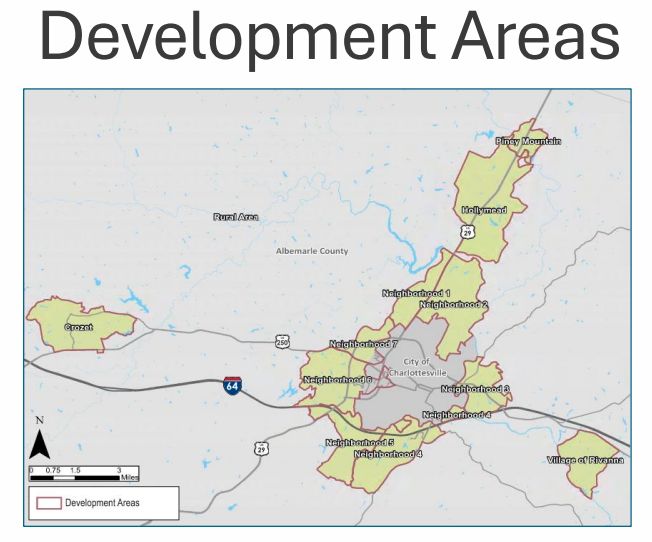
The growth area consists of roughly five percent of Albemarle’s 726 square miles and the county has a future land use map that describes what level of development is allowed on each parcel. Land use designations that allow for residential development each have a range of allowable density.
At the beginning of the AC44 process in 2022, Albemarle hired the firm Kimley-Horn to come up with a baseline of how efficiently the county is using that land. The company looked at all developable parcels of land greater than two acres and reviewed recent rezonings. Albemarle then hired the firm Line and Grade in 2025 to update the data based on what was known in the development pipeline as of April 1 of this year.
“In ‘22, our total theoretical maximum build out was just over 24,000 units,” said J.T. Newberry, a senior planner in Albemarle County’s Department of Community Development. “In ‘25, we see that that had decreased to 21,644 overall units.”

Newberry said the amount of developable land decreased during the period. As time moves on, Albemarle wants to provide incentives for property owners to redevelop land to encourage build-out toward the maximum possible.
“A big topic of interest from the Board of Supervisors was how are we doing in terms of approving projects, the density that we’re approving them at relative to the maximum under the comp plan,” Newberry said.
The 2022 analysis took a look at development from 2016 to 2021 and found that properties were coming in at 58 percent of the potential maximum. The 2025 update brought that number to 56 percent.
Newberry said this analysis is meant to be a very broad brush.
Members of the Planning Commission said not all properties are alike and decision-makers need to know specifics about infrastructure needs for each potential project.
Rivanna District Planning Commissioner Corey Clayborne asked what the utility of such a number would be and how it would tie to decisions about level of intensity.
“If you look at the current infrastructure, and I just jotted down roads and schools, nothing else, but like, does that, is that able to even accommodate the 58 percent?” Clayborne asked. “What would happen if we were able to get to the 80 percent? Would we just crumble?”
During the AC44 process, Rio District Planning Commissioner Nathan Moore was one of the voices calling for the county to at least study the idea of expanding the development area. He said he was not sure what use looking at the maximum theoretical number of units would be given there will be land use shifts over the 20 year horizon of the Comprehensive Plan as Albemarle continues a call for new business.
“I mean we’ve got economic development happening quite successfully in terms of AstraZeneca’s announcement,” Moore said. “And I think the goals continue to grow more, you know, if we make room, will that population increase more? It certainly could. And so I think we could be seeing a higher population growth and a lower number of actually buildable units. And I think we’re going to find ourselves full before this 20 years runs out.”

Commissioner Karen Firehock pointed out that many developments don’t reach the maximum potential because the public process offers opportunities for neighbors to push back against density. She suggested matching the county’s growth area zoning to match what is allowed under the Comprehensive Plan.
“That’s why I keep getting on the bandwagon of why don’t we just rezone it to what we want because it’s the going through the development process that people don’t bother trying to get the higher density,” Firehock said. “We’ve heard that time and again.”
Newberry said a new analysis tool will begin to be used in 2026 that will allow for more scenarios to be worked out for each rezoning.
“This is a first attempt at tracking how current development proposals are aligning or not to the maximum theoretical capacity as called for in the comp plan, notably under AC44,” Newberry said.

At-Large Planning Commissioner Luis Carrazana said he felt the tool will be useful in providing real-time data as new projects come up for a decision but he said the information can be used for much more.
“So let’s not just track it,” Carrazana said. “Let’s think about how we move the needle. So when we’re having the conversations with developers and, and they’re coming in at 50 percent say, well, what is it going to take to get you to 70 percent or 80 percent?”
The Board of Supervisors will discuss the analysis tool at a work session on January 21. Supervisors had a briefing on the build-out analysis back in September if you would like to review a story I wrote.
Before you go: Paid subscribers cover the cost of conducting research for this article which was originally published in the December 19, 2025 edition of Charlottesville Community Engagement. You can either subscribe through Substack, make a monthly contribution through Patreon, or consider becoming a sponsor. The goal of Town Crier Productions is to increase awareness about what is happening at the local, regional, state, and federal government levels. Please share the work with others if you want people to know things.
Discover more from Information Charlottesville
Subscribe to get the latest posts sent to your email.