A $12.1 million plan to update Emmet Street in Charlottesville could offer both the city and the University of Virginia the chance to turn a suburban thoroughfare into a place less dependent on motorized vehicles.
However the outcome of the project will depend on the totality of public comment from stakeholders.
“It’s hard to get 100 percent consensus and direction from the public because some people would say widen it and say increase the speeds to 45 miles per hour,” said Mike Callahan, a planner with the engineering firm EPR. “Most people are saying they want it more walkable and bikable and to slow the traffic, especially the University community.”
Callahan made his comments at the December 13, 2018 meeting of the PLACE Design Task Force, an advisory group formed in 2012 to advise City Council on urban design issues.
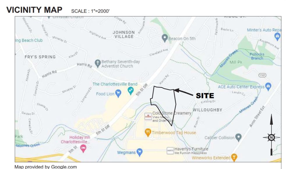
The scope of the project runs the roughly half mile between the Ivy Road and Arlington Boulevard. While most of the land along the corridor is owned by the University of Virginia or its real estate foundation, the public right of way is governed by the city. Over 25,000 vehicles a day passed through the corridor in 2017 according to traffic estimates from the Virginia Department of Transportation.
In 2016, the city was successful in obtaining the funding for the project in the first round of the VDOT’s Smart Scale program. The community engagement process began in April.
“We’re really at an important stage of locking in on the preliminary design of what the best improvements we can fit into this that will function well,” said John Stewart, an engineer with Clark Nexsen, a firm hired by the city to design the project. EPR is working as a subcontractor.
The final design will be finished next year. In 2020, the firm will begin utility relocation and right of way acquisition to prepare for a construction start date the following year.
“In early 2023 we would like to have this constructed,” Stewart said.
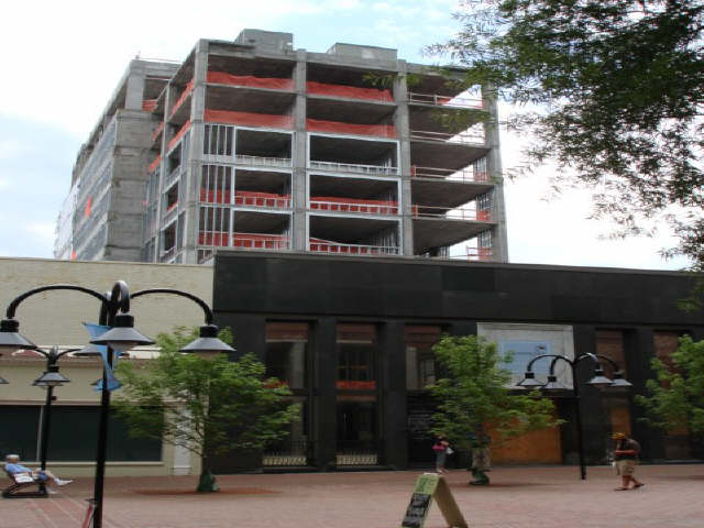
Several changes have come to the area in the past year. The University of Virginia has demolished the Cavalier Inn. In October, granted a special use permit that will allow the eighty-foot-tall Gallery Court Hotel an eight-story hotel on the site of a smaller structure that burned down in May 2017.
The streetscape project gives a rare opportunity for the city to help inform the plans of the University of Virginia. Earlier this year, the Board of Visitors approved a new master plan for the athletic facilities centered around University Hall, a structure that is also slated to be demolished.
While of the land in the area is vacant, there are homes in the corridor. The eastern side is the location of both the 174-unit Lambeth Field Apartments and the 69-unit University Gardens complex.
Working out the details
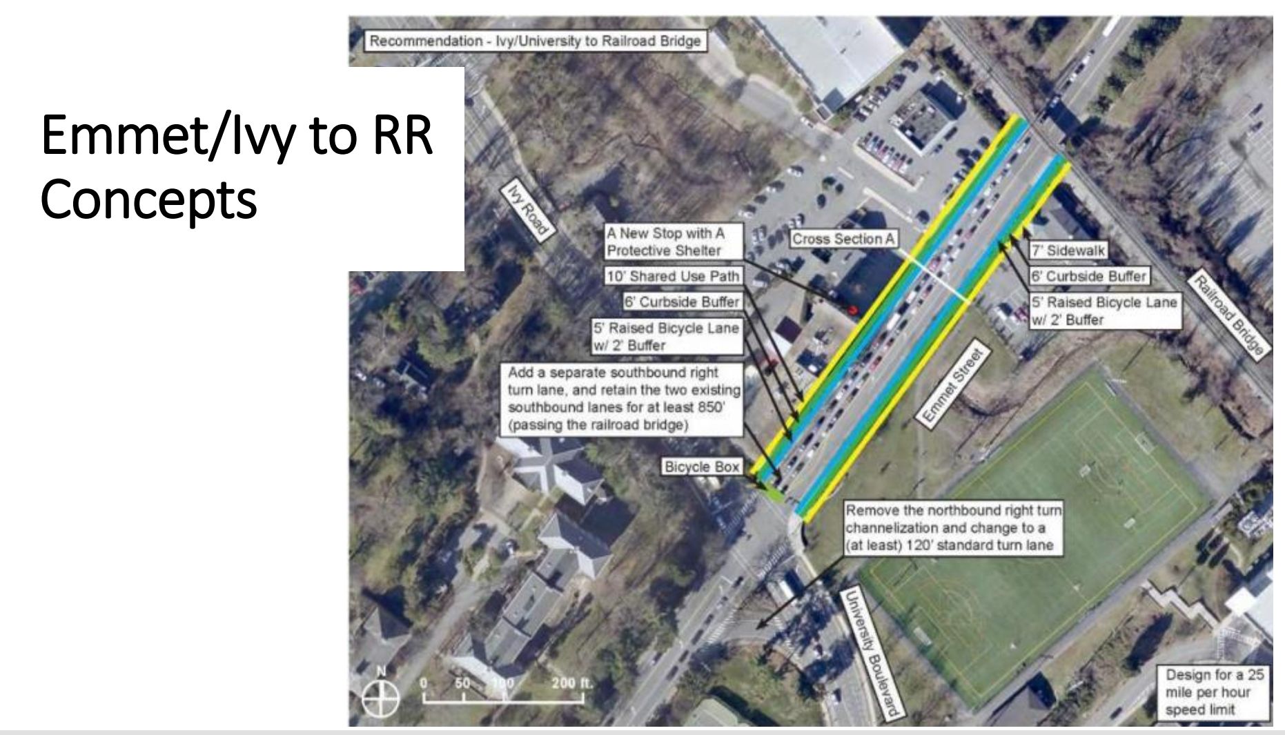
The existing public right of way in the corridor is 64 feet. The draft streetscape shows that being extended to 79 feet.
One item that has yet to be determined is the location of a shared-use path that was specified in the Smart Scale application.
“Does that go on the east side or the west side of the corridor?” Callahan asked. “We started out on the east but as we got going and talked to the steering committee and the public, a lot of concerns were raised.”
One of those was that the new hotel will be built much closer to the street than the previous structure.
“It meant the trail and the tunnel would have to go behind it,” Callahan added.
During community engagement efforts, Callahan said participants were clear that they want a physical barrier of some sort between the vehicular lanes and the bike lanes.
Another concern raised by the public is amount of time it takes to cross the intersection of Emmet Street and Ivy Road.
“We saw during our walking tour that it takes a lot of time to cross there,” Callahan said. “We want to make that a much safer intersection for bikes and pedestrians.”
UVA has plans to eliminate a lane that will allow motorists to turn into the Lewis Mountain Parking Garage from Emmet Street. That means the design team is considering adding new space for vehicles as a replacement.
“A lot of people use that according to our traffic analysis so adding a southbound right turn-lane that’s dedicated onto Ivy westbound was something people raised and we included,” Callahan said.
Another topic that has come up is whether there needs to be both bike lanes and a shared-use path in the project. The answer to this question will inform the amount of right of way that will need to be purchased or donated.
“A bike lane is going to be used by bicycle commuters going 20 miles an hour,” Callahan said. “A shared-use path is going to be better for those bicyclists that are more recreational and those who don’t feel that comfortable being that closer to [vehicular] traffic.”
City Councilor Kathy Galvin, an ex officio member of PLACE, pointed out that the John Warner Parkway has bike lanes as well as a shared-use path.
“If I’m in a rush and in more of a contemplative mode, I’ll go on the multi-use trail,” Galvin said.

Can the road be slowed down?
While one stated goal of the project is to make Emmet Street safer and welcoming for non-vehicular traffic, Galvin expressed concern existing conditions would make that difficult.
“My concern is that it’s just going to be a very fast road no matter what you do because you don’t have buildings on the edge of the right of way,” Galvin said. “You have nothing but an open field. Eventually there will be buildings on the west side but on the east side it will be [mostly] empty.”
Frustrated by the apparent widening of the Ivy and Emmet Street, a PLACE member who is a assistant professor in the UVA School of Architecture suggested removing that turn lane from the concept and routing vehicles bound for the parking garage to turn left onto Massie Road and then Copeley Road instead.
“This then becomes a viable pedestrian and bicycle Complete Street from Massie Road down to Ivy,” said Andrew Mondschein.
However, the scope of the streetscape doesn’t cover that possibility.
“It may be outside the scope but it’s up to the city to decide on a turn lane,” said Mike Stoneking, chair of the PLACE Design Task Force and himself an urban designer.
The University of Virginia’s Office of the Architect is developing a long-term plan for the Ivy Road corridor. No representatives from the office were at the PLACE meeting, but Galvin remarked that the draft plan calls for the Cavalier Inn site to remain open space.
“When the University just wants to keep open space at its gateway, it is just going to be a fast road,” Galvin said. “You’re not going to get any notion of place until you get to the Barracks Road area.”
In contrast, Mondschein argued there are opportunities due to the future hotel and the fact that traffic has to slow down once it travels north on Emmet into Grounds, where the speed limit is already 25 mph.
In recent years, Council has made several land use decisions to allow autocentric uses on Emmet Street between U.S. 250 and Barracks Road, such as a car wash at 1300 Emmet and a drive-through for a restaurant at 1248 Emmet Street. Galvin said those decisions have limited the ability to turn the rest of the roadway into a place more befitting for pedestrians.
“That boat has sailed and the only thing I can see as probably creating an urban place is at the intersection of Barracks and Emmet,” Galvin said. In 2017, the city received $8 million funding through another Smart Scale project to address that intersection. That project has not yet begun.
A developer who serves on the PLACE group said there are market reasons for why autocentric uses are prominent in that section of the street.
“There is overwhelming private sector demand for that type of use,” Henry said. “When you have 30,000 cars on the street, it’s like flies to honey for fast food.”
However, PLACE members were adamant that this streetscape project help inform a future where fewer people drive.
“I believe that from the bypass down to [Ivy Road] it’s going to be a tight urban condition one day,” Stoneking said. “The sooner the infrastructure projects that, the better.”
Stoneking summarized that PLACE would like to see a design with shared-use paths on both sides of the road, want to minimize widening of the Emmet and Ivy intersection and wants to find a way to improve the design of the passageways that travel under the railway embankment.
The project went before the Charlottesville Planning Commission on December 18, 2018.
Before you go: This article was written before Town Crier Productions was created. At the time I was not a working journalist. I wanted to get back to it because it’s the only thing I’m good at, though many might dispute that. Either way, I’m grateful to do this work.
Discover more from Information Charlottesville
Subscribe to get the latest posts sent to your email.