The Albemarle Board of Supervisors adopted the Places29 Master Plan in February 2011 to guide development in the county’s largest growth area. One of the sub-areas goes by the name “Neighborhood 2.”
“With 2,981 acres, Neighborhood 2 is the second largest of the Northern Development Areas,” reads page 21 of the plan. “The eastern and northern boundaries are the Rivanna River/South Fork of the Rivanna River, US 29 is the western boundary, and the southern boundary is the City limit.”
According to data provided by Albemarle’s Community Development Department, there are 814 residential units in this area that have been approved but not yet built. There are another 972 units that are under review.
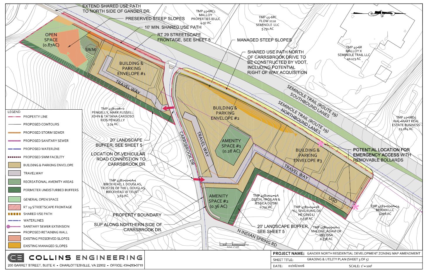
That includes a request from the United Land Corporation for a rezoning of between 80 and 237 units on four parcels on U.S. 29 totaling nearly eight acres at the entrance to the Carrsbrook neighborhood.

Two of the parcels are zoned for Commercial Office and one is zoned for Highway Commercial.
A fourth is zoned R-1. The two commercial properties are designated Commercial Mixed Use, the Highway Commercial parcel is designated Office / R&D / Flex / Light Industrial, and the residential property is designated Neighborhood Density Residential.
“The Project aligns with the surrounding residential uses while maintaining a higher density than single-family residential that is better suited for frontage along the Rt 29 corridor, providing much needed housing within Albemarle County’s development area,” reads the narrative dated February 16, 2026. “The Project proposes a minimum density of 10 units per acre and a maximum density of 30 units per acre.”
According to the site plan, one building envelope would be on the south side of Carrsbrook Drive and two others would be on the north side. Vehicular access would be from Carrsbrook Drive with no direct access to U.S. 29. Emergency access would be made through a parcel on U.S. 29 to the north.
Construction is under way for a ten-foot-wide shared use path funded in the fourth round of the Virginia Department of Transportation’s Smart Scale process.
A community meeting for the project was held on January 22, 2026 at the Places29-Rio Community Advisory Committee.
Staff in the Community Development Department have twice issued letters of denial which are a routine part of the process. Staff recommended the applicant ask for a deferral to revise the plans to address concerns with sight distance for the vehicular entrances as well as additional work to determine if a stream on the property requires protection and mitigation from impacts.
The United Land Corporation took the deferral and are now making the revisions.
Before you go: The goal of Town Crier Productions is to increase awareness about what is happening at the local, regional, state, and federal government levels. Please share the work with others if you want people to know things. Paid subscribers cover the cost of conducting research for this article which was originally published in the April 27, 2026 edition of Charlottesville Community Engagement. You can either subscribe through Substack or make a charitable contribution.
Discover more from Information Charlottesville
Subscribe to get the latest posts sent to your email.