George Mason University has taken the lead on producing a document that brings together research on how Virginia’s weather patterns are changing and what steps are being taken to mitigate and adapt.
The Virginia Climate Assessment was published earlier this month.
“As the first report of its kind for the state, it provides a collection of evidence-based key messages that have been prepared and extensively reviewed by technical and scientific experts across Virginia and beyond,” reads the executive summary.
The report is a must-read for anyone interested in learning more about the various risks facing the Commonwealth. The assessment contains a description of Virginia’s geographic diversity.
“Virginia is a climatically diverse state comprised of 27 different ecoregions and 6 climate divisions that span across state and county borders,” the assessment continues. “These ecoregions span plains, mountains, and coasts.”
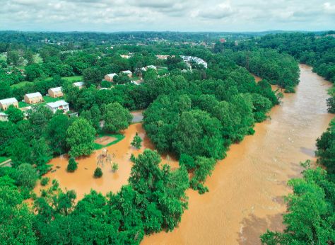
Data dating back to 1776 indicates a trend to a wetter and warmer conditions over the years with greater temperature swings possible throughout the whole year noting a period in January 2024 when Charlottesville experienced a high temperature of 79°F on one day followed by a high temperature of 28°F eleven days later.
The report notes the threat of sea level rise on coastal areas but also notes that all parts of Virginia are at risk. The idea is to periodically update the assessment with more data and more coordination.
The report notes that the wetter and warmer trend is expected to continue.
“Projections for Virginia’s climate, which align with those for the global climate, indicate continued and significant warming through the end of the 21st century,” reads a portion of page 14. “The magnitude of this warming is contingent on the global greenhouse gas emissions pathway taken.”
Under the most extreme emissions scenario, mean air temperature could rise between an additional 7°F and 13°F.

Before you go: Paid subscribers cover the cost of conducting research for this article which was originally published in the November 26, 2025 edition of Charlottesville Community Engagement. You can either subscribe through Substack, make a monthly contribution through Patreon, or consider becoming a sponsor. The goal of Town Crier Productions is to increase awareness about what is happening at the local, regional, state, and federal government levels. Please share the work with others if you want people to know things.
Discover more from Information Charlottesville
Subscribe to get the latest posts sent to your email.